Monday, December 19, 2011

Let's go surfing in the sky!

A large crashing ocean wave is a surfer's dream.  It's something they can ride their surf board on and potentially through, if they are really good!  But now imagine surfing in the sky?  Where would you get those amazing waves to ride, and what would they look like?  Well, wonder no more!


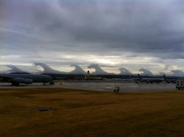
This picture was taken the morning of Friday, December 16th overlooking Birmingham, Alabama.  Large cresting waves were seen on the horizon and they really confused many of the locals.  The local television stations had many people calling in wondering what exactly was going on.

What they were actually seeing are "Kelvin-Helmholtz waves".  These waves form when a fast-moving layer of fluid slides over a slower and thicker layer of fluid, thereby dragging its surface.  For example, water waves form when the air (yes, air is considered a fluid) is moving faster than the water below.  When the difference between the wind and water speed is great enough, the waves "break" (their crests lurch forward) and they take on the classic shape of a Kelvin-Helmholtz wave as seen above!

So what happened here is that there was more than likely a slow moving cold layer of air near the surface (as evident by the thick cloud layer).  A warmer, faster moving layer of air aloft rode over top of it.  And since the cold air is denser and slower than the light, fast-moving warm air, the warmer air dragged and began scooping up the top of the cold layer, resulting in the cresting waves that appeared in the cloud!  Pretty cool, right!

Monday, December 5, 2011

Is it Partly Cloudy?

I often get  questions from people regarding how meteorologist define certain sky conditions.  You often here the phrases Cloudy, Mostly Cloudy, Partly Cloudy, Partly Sunny, Mostly Sunny, Mostly Clear, and Clear in weather forecasts.  But many don't know the distinction between some of these terms, especially between Partly Cloudy and Partly Sunny.  These two terms seem to confuse people the most, but I will go through them all, just for your knowledge.  So here we go!

Cloudy
This one is an easy one that most people can recognize.  The sky is cloudy when it is completely covered in clouds, typically when an area of low pressure moves through the region.  Many meteorologists define a cloudy sky as one where there is less than 10% of clear sky visible, while others state that it must be absolutely free of clear sky.  I'm one of the type that say where there is less than 10% clear sky, it is cloudy!

Mostly Cloudy
This one too is easy to recognize but can be a bit tricky on one end of the spectrum.  I typically define a mostly cloudy sky as one where there is between 10% and 30% clear sky visible.  That's right, a mostly cloudy sky can have a few breaks here and there.  But it can get a bit tricky with the more clearing you get, as it becomes partly sunny!  (However, at night time there is no problem as night can not be partly sunny!)

Partly Sunny
This term is one of those that can easily confuse people since it's right between mostly and partly cloudy.  It has more sun that a mostly cloudy sky, but more clouds than a partly cloudy sky.  Generally, a sky with 25% to 40% of clear sky can be described as partly sunny (unless it's night).

Partly Cloudy
This one I like to divide into day and night portions since it actually has a wider range at night.  During the day, a partly cloudy sky typically has about 40% to 75 % of clear sky visible.  However, at night that range increases to 30% to 75%.  Why?  Well, a sky that is 30%  to 40% clear during the day is considered Partly Sunny, but since there is no sun at night, it becomes Partly Cloudy!

Mostly Clear/Mostly Sunny
These are days that everyone seems to love.  Plenty of sunshine with just a hint of a few clouds scattered here or there.  They allow for quick warming during the day, but also quick cooling at night - the reverse of their mostly cloudy counterpart.  A mostly clear sky can be defined as one with 75% to 95% clear sky.

Clear/Sunny
No clouds.  No rain.  No problems.  Well... not exactly.  Clear skies can be a delight, but they also accompany extreme heat waves and cold air outbreaks across the globe.  They obviously let in a lot of sunlight during the day (plus during the winter, all that sunlight is reflected off of the snow!), but also release a lot of heat at night!  A clear sky is one where there is less than 5% cloudiness in the sky (a.k.a. barely a wisp of a cloud).

I hope this clears things up a bit, but if it doesn't just let me know and I can try to go into further detail!  Until next time, keep your eye on the sky!

Thursday, November 17, 2011

2011 - 2012 Winter Weather Outlook

Hello everyone!  As meteorological winter (December through February) approaches, I though it would be good to give you a heads up as to what you may expect for the next several months - at least weatherwise. 

As I have mentioned in an earlier post, the La Nina that we dealt with last winter faded away this past summer.  Unfortunately, it has made a comeback and will likely play a role in our weather patterns across the nation for this winter.  In addition to La Nina, the lesser known and less predictable Arctic Oscillation could influence our weather as well with large short-term temperatures swings.  As a result of these large temperature swings and strong shifts in the climate patterns, the Arctic Oscillation could overwhelm or amplify the impacts typically seen from a La Nina!

So here is what the scientists at NOAA are predicting for the 2011 - 2012 weather season.

The northwestern US and eastweard into the Great Lakes region will likely see wetter conditions for the winter months, which could mean more snow than normal!  In addition, much of this area, especially the Missouri and Mississippi River Basins saw massive flooding last spring due to so much snow melting from the last La Nina winter.  The increase in precipitation again this winter could once again mean another season of flooding for these river basins!  And on the flip side, areas that need the precipitation the worst are less likely to see it.  The southern US, which is already facing a drought not seen in decades in some areas (namely Texas and Oklahoma), is expected to be much drier than normal.  So the drought will likely continue into next year.  Below, you can see an image of this thanks to the folks at the Weather Channel.


As far as temperatures, that's were it gets a bit tricky.  Typically, a La Nina will bring much cooler conditions to the Northern Plains, Great Lakes, and the California coast with warmer conditions for the South Central U.S.  And this is what is expected for this winter as well (as you can see below in the image from the Weather Channel).  However, the tricky part comes from the Arctic Oscillation (remember him?... we'll just call him A.O. from here on out!).  The negative phase of the A.O. pushes cold air into the U.S. from Canada that typically lasts a few weeks and are very difficult to predict more than a week or two in advance.  The A.O. went strongly negative at times the last two winters and caused outbreaks of cold and snowy conditions across the U.S., including the ice storms that affected the Dallas, TX area before the Super Bowl last January and the massive snow storms across the East Coast the past two winters.  The strong negative A.O. also increases the snowfall amounts around the Upper Midwest as well, along will bitterly cold conditions (below -25F anyone?).  Okay... I think I just sent a shiver up your spine with that comment!


With the much cooler conditions for the Upper Midwest this winter, maybe now would be a good time to take a trip to Hawaii... it's anticipated that they will be warmer and drier than normal!  But to recap, I am expecting a cold and snowy winter for us here in Wisconsin & Minnesota with plenty of temperature swings to keep things interesting!  I hope you have your snow shovels handy!  Until next time, have a great day and stay warm!

Tuesday, November 15, 2011

Winter Weather Safety Reminder!

Wow.... it has been way to long since I last posted.  I guess I'm still getting use to blogging, even after a year!  Anyways, I think now would be a good time to review some winter weather terminology and safety tips.  I know most of you have heard this before, but it's something that is very vital for living in the Upper Midwest between November and late March!  So here we go!


First, lets start with the watches, warnings, and advisories you typically hear about this during the late fall, winter, and early spring months and what they actually mean!

Winter Storm Watch
A Winter Storm Watch is issued when there is a potential for a winter storm to affect the region during the next 1 to 3 days. It does not always mean the area will be hit by a winter storm, but there is still some uncertainity of the exact path or timing of the event. This is a planning stage. Use this time to ensure you have supplies at home, like some extra food, medications, baby items, etc.. If travel is planned, check ahead and see if a different route or delaying your departure may make your trip safer. Be alert for changing weather conditions.


Winter Weather Advisory
Advisories are issued for those winter weather events that are expected to be more of an inconvenience and should not become life-threatening if caution is exercised. These are often issued for 3 to 6 inches of snow, blowing and drifting snow, freezing drizzle, or a combination of these elements. It may be issued for less snow for early season events, when drivers may not be accustomed to slick roads.


Winter Storm Warning
Winter Storm Warnings are usually issued when dangerous winter weather is expected, occurring, or imminent. The weather can become life-threatening. Criteria includes snowfalls of 6 inches or more in 12 hours, 8 inches in 24 hours, or lower amounts if accompanied by strong winds or a combination of dangerous winter elements. Avoid unnecessary travel.


Blizzard Warnings
The most dangerous winter event is certainly the blizzard. Blizzard Warnings are issued when snow or blowing snow lowers visibilities to a 1/4 mile or less, wind gusts hit 35 mph or higher, and the storm lasts for 3 hours or more. Travel is dangerous and should be avoided if possible.


Ice Storm Warning
Ice storm Warnings are issued when freezing rain will cause widespread glazing. A coating of ice is expected to reach 1/4 inch thick or more on objects and make travel nearly impossible. For lesser amounts of ice, usually a winter weather advisory would be used, but even a thin glaze of ice can make travel difficult. Avoid travel.


Wind Chill Warning
Issued when wind chills of -35 F or lower are expected with wind speeds of 10 mph or more. A wind chill advisory is issued for values between -20 and -34 F. Dress warmly and cover as much exposed skin as possible.

*********************************************************************************

Now, here are some tips to keep in mind when nasty winter weather comes your way!

Proper winter weather awareness includes preparation. Here are some things that can help you.


When Outdoors:
  • Check temperatures and wind chill indicies first.
  • Dress warmly, with several layers. Dress for the worst just in case.
  • Use a warm coat, gloves or mittens, a hat, and water-resistant boots.
  • Cover exposed skin as much as possible.
  • Watch for frostbite on finger tips, ear lobes, the nose, or toes.
  • Avoid over-exertion. The cold already puts a strain on the body and heart.
At Home or Work - make sure you have:
  • Extra flashlights and batteries
  • A battery-powered NOAA Weather Radio or AM/FM portable radio
  • Extra food and water (2-3 day supply)
  • Extra medicine and baby items
  • First Aid supplies
  • Emergency Heating source**
  • Carbon Monoxide Detector
** If you use an emergency heating source, be alert for deadly carbon monoxide gases and never place it near another object that may catch on fire. Many house fires during the winter are caused by incorrect use of a space heater. Keep the space heater at least 36 inches away from other objects and turn it off if you leave the room.

On the farm:
  • Move animals to a sheltered area.
  • Supply extra food for animals.
  • Have a fresh water supply (most animal deaths during the winter are from dehydration).
At School:
  • Have an action plan.
  • Monitor weather conditions closely.
  • Use NOAA Weather Radio to get hourly wind chill values.
  • School days may need to be delayed, cancelled, or shortened.
When Traveling:
  • Winterize your vehicle. Check the battery.
  • Check the forecast and road conditions ahead of time.
  • Consider adjusting your route to avoid poor driving conditions.
  • Carry a cellular phone for use during emergencies.
  • Keep the gas tank near full.
  • Coordinate with others your destination and times of travel.
  • Yield to snowplows. The snow cloud they produce can lower visibilities to near zero. Stay back - Stay Alive!
  • Have a survival kit in your car:
    • Extra blankets or sleeping bag
    • Flashlight with extra batteries
    • First Aid kit with pockey knife
    • Booster cables
    • A rope
    • A small shovel
    • A bag of sand or cat litter for traction
    • Plastic bags (for sanitation)
    • Extra gloves, hat, and socks
    • Non-perishable food items and bottled water
    • Road maps (for alternative routes)
  • If you do get stuck:
    • Stay with your car. Do not try to walk to safety.
    • Start the car for about 10 minutes every hour for heat.
    • Keep the exhaust pipe clear of snow.
    • Tie a bright colored (red or orange) cloth to the antenna.
    • Turn the dome light when running the engine.
    • If you must venture away from the car, use a life-line or rope.
  • Be careful of Dense Fog. Delay your travel if needed.
    • Do not drive into a dense fog bank. Others may be stopped.
      • In October 2002, a pile-up on Interstate 43 in eastern Wisconsin killed 10 people (see image) during dense fog.
      • In January 2008, another series of accidents in southern Wisconsin led to some fatalities due to dense fog.

 There... I know that was a really long read, but there is a lot of useful information there!  Hopefully, this will aid you this winter as the snow begins to fly around the Upper Midwest.  Until next time (which will hopefully be soon!), have a great day!

Friday, October 7, 2011

Have you ever seen a quadruple rainbow????

Rainbows are one of nature's little gifts after a shower or storm that can quickly bring a smile to your face. Many people have seen these beautiful arcs grace the sky with their presence, and several people have likely seen double rainbows as well, even though they are far less frequent. But what about a triple or even a quadruple rainbow? Many in the scientific community long believed that they were as real as the lost city of Atlantis. But believe it or not, recent photographic evidence has proved that triple and quadruple rainbows are very real.... and very rare!

A new meteorological model has allowed meteorologists to find and capture the extremely rare phenomenon known as a tertiary, or triple, rainbow. And very recently, an amateur storm chaser in Germany went even farther and found and captured the exceptional event of a quaternary, or quadruple, rainbow. You will find his picture below. Sightings of tertiary (triple) rainbows are incredibly rare. In fact, there have only been 5 reported instances in the past 250 years! But with this new method on hand, two photos have come to light in the past few months - both showing the tertiary band and one revealing the first-ever photographed quaternary band.

The first picture ever of a quadruple rainbow shows the third-order (left) and fourth-order (right) rainbows. The first two aren't included in the image.


Now you may ask yourself, where do these unique rainbow form. The answer, look where you'd least expect! Imagine yourself in an open field, seeing the bright primary and secondary rainbows before you. To see the tertiary and quaternary rainbows, you need to look back towards the sun, about 40 degrees towards it.

Like the primary and secondary rainbows, the third and fourth order bands occur when sunlight bends as it moves through water, a process known as refraction. The curvature of raindrops within storms helps to bend the colors in sunlight at slightly different angles, dispersing them and separating them into the familiar red, orange, yellow, green, blue, indigo, and violet bands of a rainbow. Most often, the multicolor bands pass right through the raindrops, but when they are reflected, they produce a primary rainbow at approximately 138 degrees from the sun. Double rainbows occur when some of the sunlight is reflected back through the raindrops and the process is repeated. However, each time the process is repeated, the resulting rainbow is fainter, which makes the tertiary and quaternary rainbows so rare.

However, the conditions to see these rare rainbows are very tricky to find. You need an pitch black sky behind the rainbows (in order to see them), you need direct sunlight, so there needs to be a break in the clouds letting the sun in (or you'll have no rainbow at all!), and it also helps to have torrential rainfall occurring. Then, you may also have to enhance the contrast of the picture enough so that the rainbow can be seen with the naked eye. It's that tricky.

But if you ever find yourself in this perfect set up and you have a camera along, be on the lookout for these elusive rainbows. The results may just take your breath away!

Friday, September 23, 2011

Welcome to Autumn!

Greetings everyone!  I realize it has been a while since I wrote on here and I'm sorry about that.  Time has really flown the past several weeks!  And the weather has changed quite a bit too!  Since my last post, we went from a summer heat wave to temperatures today struggling to get out of the 50's!  What a change!  In a way, these fall like conditions we have in Wisconsin right now is perfect to welcome in autumn with!  Autumn officially arrived to Wisconsin around 4:04 A.M. CDT this morning. 

This is known as the autumnal equinox, the time when the sun's direct rays cross over the equator into the southern hemisphere, signaling the end of winter there and our summer here.  As a result, you will likely notice the days getting shorter very quickly from day to day as we loose more sunlight thanks to the northern hemisphere tipping away from the sun.  In turn, our daily average temperatures will also start to drop, so I hope you're ready for the cooler conditions!  It's hard to believe the cold and snow of winter is just around the corner!  Until then, have a great day, and I'll try to post here more often!

Thursday, August 4, 2011

2011 Hurricane Season

Wow, it's been a while since I last wrote.  Sorry about that.  Anyways, now that we are into August, we have entered the peak of the typical hurricane season.  Hurricane activity in the Atlantic Ocean is the highest between August and October.  And this year appears to be an above normal year in hurricane  activity.

NOAA is anticipating 14 to 19 named storms (which included Tropical Storms and Hurricanes, and we've already had 5 tropical storms this year - Arlene, Bret, Cindy, Don, and Emily).  Seven to ten of these storms are anticipated to be hurricanes, half of which could be major hurricanes (Category 3, 4, or 5).  These numbers are actually higher than the prediction NOAA made back in May.

So why the increase in the number of storms in the forecast?  Here's why:

"Key climate factors predicted in May continue to support an active season. These include: the tropical multi-decadal signal, which since 1995 has brought favorable ocean and atmospheric conditions, leading to more active seasons; exceptionally warm Atlantic Ocean temperatures (the third warmest on record); and the possible redevelopment of La Niña. Reduced vertical wind shear and lower air pressure across the tropical Atlantic also favor an active season." http://www.noaanews.noaa.gov

Basically, all the right ingredients are coming together at the right time, resulting in prime conditions for an active hurricane season.  So if you live or have plans along the Gulf or East Coasts between now and October, keep an eye on the latest forecasts.  Forecasts provide a lot of advanced warning when it comes to hurricances and tropical storms, so you won't get caught by surprise.  But keep checking the forecast if your going on vacation.

Thursday, July 7, 2011

El Nino, La Nina, and.... La Nada????

Odds are you've heard of El Nino and La Nina (the abnormal warming and cooling of the eastern equatorial Pacific waters, respectively), especially if you've been reading my blog.  This past winter, the Pacific Ocean was in a very strong La Nina, which helped to produce the heavy snows and cold winter across the U.S., along with the severe drought conditions over the southern U.S. this year.

Late last winter, the strong La Nina that helped to ravage the nation early last winter finally came to an end and the Equatorial Pacific waters returned to their normal temperatures.  But this presents it's own issues.  Usually, when a La Nina period ends, an El Nino period begins, even if it's just a weak one, and vise versa.  So the waters off the coast of western South America never stay normal for very long.  But this year, we are seeing an unusually long period of near normal water temperatures.  In fact, one scientist, Bill Patzert, a climatologist and oceanographer at NASA's Jet Propulsion Laboratory has coined the term "La Nada" to describe this period of normalcy.
The latest satellite data of Pacific Ocean sea surface heights from the NASA/European Ocean Surface Topography Mission/Jason-2 satellite show near-normal conditions in the equatorial Pacific. The image is based on the average of 10 days of data centered on June 18, 2011. Higher (warmer) than normal sea surface heights are indicated by yellows and reds, while lower (cooler) than normal sea surface heights are depicted in blues and purples. Green indicates near-normal conditions. (Credit: NASA/JPL Ocean Surface Topography Team)

The problem lies in climate forecasting.  A "La Nada" period brings with it a large amount of uncertainty in the forecasts.  Many scientists believe that a "La Nada" period will bring about "normal" weather conditions, however, previous similar "La Nada" periods have delivered unruly jet streams and wild weather swings, going from one extreme to the next.  And we actually saw this!  As the La Nina ended and "La Nada" began, the jet stream was able to swing back and forth across the U.S. wildly and helped to bring the blizzards to the Midwest, South, and Northeast, along with the tornadic storms across the South and Tornado Alley. 

However, some climatologists are wondering if another warm El Nino pattern will soon emerge - which would be great timing for the United States!  If an El Nino pattern were to develop this summer, much needed rains would likely come to the drought and wildfire stricken southern U.S.  Plus, a late summer El Nino pattern also dampens the hurricane season in the Atlantic, which peaks in late August & September.  Thus, it would bring much needed rain to the South along with a mild hurricane season!

Climatologist and Oceanographers will continue to monitor the progress of the "La Nada" and watch for signs of an emerging El Nino or a returning La Nina.  Until then, try to enjoy your summer!

Tuesday, June 21, 2011

Happy Summer! ... and why so much rain???

Summer has officially arrived to the northern hemisphere!  Summer officially arrive at 12:16 p.m today - while you were probably enjoying a good lunch.  This also means that today is the longest day of the year.

However, it sure didn't feel like summer around the Upper Midwest today.  A strong low pressure system has been influencing the region since Monday evening and will continue to linger through the day on Thursday before finally moving out on Thursday night.  Some of these storms have had heavy rain with them as well.  There is so much moisture available for this storm system that's it's not funny!    Luckily, warmer and drier conditions will return by the weekend.  By why is this storm so powerful?

It actually because of the monsoon that has been going on over southeast Asia and the Philippines.  Energy from the monsoon has managed to follow the jet stream across the Pacific and reform into storms just off the west coast.  As the new storm then moves across the Rocky Mountains, it meets a lot of available moisture in the Mississippi River Valley.  This is due to the flow around an upper level ridge of high pressure over the Southeast U.S. pumping the moisture in from the Gulf of Mexico.  Add to it a slowly moving weather pattern and you get a good soaker.

Many areas in the Upper Midwest are currently seeing floods (along the Missouri River - record flooding... yikes!) while other areas are under flash flood watches.  I got to experience a flash flood indirectly on Sunday morning as over 5 inches of rain in under 3 hours created a flash flood in the valleys around SW Vernon/NW Crawford County.  The resulting flash flood wiped out my Internet and phone connection making it impossible for me to forecast weather.  It also wreaked havoc on the rural road infrastructure in the region.  Not good.

Anyways, let's hope we don't get any more rain for a while.  We've had enough.  There are other areas of the country that need it worse - like Texas, Arizona, New Mexico, and the other drought stricken areas of the Southern U.S.

Until next time, stay dry - and Happy Summer!

Friday, June 3, 2011

What's with all the tornadoes this year?

I've been asked this by many folks this spring.  While the process of tornado formation is rather complicated, you basically (very basically) only need three things to happen.

1.) Warm, moist air riding over cold, dry air.  This basically describes a frontal boundary.  While tornadoes are certainly possible along a warm front, they are more common along a cold frontal boundary.  At a cold front, cold, dry air pushes under warm, moist air and forces it up.  This creates the atmospheric lift needed to form thunderstorms, especially supercell thunderstorms - from which the monstrous EF2 through EF5 tornadoes are born.

2.) Wind shear.  This is basically just a fancy meteorological term for a change in wind direction and speed with height.  For a tornado to form, you need to have wind at the surface moving in a different direction that at upper levels (basically the warm, moist air needs to be going one way and the cold,dry air another) and at different speeds.  This shear creates a rotation in the atmosphere parallel to the ground.

3.) An updraft.  This is provided by the parent thunderstorm from which the tornado forms.  An updraft (or vertically rising column of air) is what feeds a thunderstorm.  When the updraft of the thunderstorm meets the horizontally rotating column of air, the updraft bends the rotation into the vertical.  This creates the rotation of the supercell thunderstorm, and ultimately the tornado.

But why so many this year?  Well, in a way, it's a "perfect storm".  I know, bad pun.  But conditions this spring were perfect for tornado development over the southern and central United States - a set up only seen once in about 30 years!  First, unseasonably warm air over the Gulf of Mexico (caused by warmer than normal water there) moved into the southern and central U.S. early this spring.  Meanwhile, people in the North Central U.S. were experiencing an unseasonably cool spring.  As these two air masses clashed in the southern and central U.S., the jet stream (a rapidly flowing current of air in the upper atmosphere) dipped far to the south, creating insane amounts of wind shear over the area where these two air masses collided.  This allowed the thunderstorms created by the clashing airmasses to grow rapidly and become extremely severe and producing large, long tracked tornadoes.  And unfortunately they passes through large metropolitan areas - thus putting a large amount of people in their paths.

As we moved into late spring, the jet stream lifted back to the north as an upper level ridge formed over the southeastern U.S.  So the southern and central U.S. now has a break from severe weather.  Hopefully this remains quiet around the rest of the nation now.

Wednesday, May 11, 2011

Red in the morning.....

We've all heard this common saying: "Red sky in the morning, sailor take warning.  Red sky at night, sailor's delight!".  We were taught it as young children by our teachers and parents.  But does this and other common weather folklore actual have some truth behind them?  Below are some of my favorite sayings I've known and an explanation as to whether there is any truth to them or not.  If you have a saying you want me to try to "put to the test", comment below!

"Red sky at morning, sailor take warning.  Red sky at night, sailor's delight."

This lore does have some truth to it.  In the northern hemisphere, weather systems generally move from west to east across the globe.  Thus to have red clouds, the sun must shine on the undersides at either sunrise or sunset when the light from the sun passes through a large amount of atmosphere.  This results in the scattering of most of the shorter wavelengths of the visible spectrum (purple, blue, green) leaving behind the red end of the spectrum.  If the skies are red in the morning, this is because there is clear skies and high pressure to the east, allowing the sun to shine from that direction underneath clouds moving in from the west - typically ahead of a low pressure system bringing a chance for rain.  If the skies are red at night, the sunlight is coming in from clear skies to the west, signaling the approach of clear skies, high pressure, and fair weather.

"If birds fly low, then rain we shall know."

This too holds some truth.  A drop in air pressure will cause the air to become heavier and make it difficult for birds to fly at higher altitudes.  And a drop in pressure signals the approach of a low pressure system, bringing rain to the area.  The birds will also fly low to catch bugs (also flying low due to the heavy air) before the storms move in.

"If a circle forms 'round the moon, 'twill rain or snow soon."

A halo/circle around the moon is caused by light being refracted as it passes through ice crystals in high level clouds.  These high level clouds are often (but not always) a sign of an advancing low pressure system (the high clouds are typically the left over tops of cumulonimbus clouds that got blown away at high altitudes).  While rain or snow may not always follow, the presence of a halo around the moon provides a high probability of wet weather in the near future.

"From twelve 'til two tells what the day will do."

This one has no truth behind it at all.  There have been countless occurrences of nice clear weather in the early afternoon giving way to violent thunderstorms during the evening hours.  Plus, when you look at it, by noon, half the day is over with - so you already know what it has done!

"Clear moon, Frost soon."

This one does hold some truth.  In the fall and spring, a "clear" moon, or clear sky where you can see the moon, allows for perfect radiational cooling (allowing the daytime heat to escape to space).  When radiational cooling happens, overnight temperatures will drop quickly, and can lead to the formation of frost if temperatures get cold enough.  But obviously, this does not hold true for the summertime when overnight lows rarely dip to the freezing point.

"No weather be ill, if the wind is still."

Calm conditions (usually accompanied by clear skies, but not always) usually indicates the dominance of high pressure over the particular area.  Since highs are large areas of sinking air, they discourage the formation of clouds, strong winds, and precipitation.  On the other hand, most people have heard of the saying "the calm before the storm" in which conditions, including winds, go calm just before a large thunderstorm moves through.  Such a storm would be visible to the west though.  One more occasion in which this lore may not hold true:  in the winter time, calm air and clear skies may signal the approach or presence of an Arctic high which is typically accompanied by VERY cold air.  And it is very difficult to imagine temperatures of -30 to -40 F as pleasant.  BRRRRR!

"A cow with its tail to the west makes the weather best, A cow with its tail to the east makes the weather least."

I know this one from being raised on the farm.  Cows prefer not to have the wind blowing in their faces... it does not make them very happy!  So, as a result, they will typically stand with their backs to the wind.  Since west winds typically mean arriving or continuing fair weather (but not always) and east winds signal the approach of arriving or continuing unsettled weather (again, not always), this lore does hold a bit of truth.

Monday, May 2, 2011

How clean is your air?

How clean is the air you're breathing?  That's the quesiton you should ask often as it could impact your health!  This week, May 2 - 6, is Air Quality Awareness Week across the nation.  How clean the air we breathe is extremely important for our day to day lives.  The main trouble makers with air quality are low-atmospheric ozone and particulates (blowing dust particles and other substances).  On days when air quailty is very low (usually occurs when high pressure settles into an area with very light to calm winds), the NWS will actually issue an Air Quality Alert for the affected area and action days may be declared. On action days, the government urges people to cut down on their number of emissions (or how much they pollute the air) by using public transportation (they may even let you ride for free - but you have to check) and other various ways.

One way to check on the quality of the air in your area is to check www.airnow.gov .  This website will show you the current quality of the air you're breathing and also provide you with a forecast for the next day.  To learn more on air quality, I suggest you check out http://www.airquality.noaa.gov/ . 

Thursday, April 14, 2011

Water, Water Everywhere!

Another element that can arise from severe thunderstorms is the threat of flash flooding.  Flash flooding typically occurs when an area that has extremely saturated soil receives heavy rains (or even light to moderate rain over a long period of time).  Flash flooding becomes even more dangerous in areas where topography can lead to water moving extremely fast down hill, such as mountain ranges... or the bluffs, ridges, and valleys of our very own Coulee Region.
Flash floods are the number one weather-related killer in the United States.  Flash floods are capable of moving boulders, removing trees, damaging buildings and bridges, and can even change the course of rivers and streams!  One such event happened in August of 2007 here in the Coulee Region.  Parts of La Crosse and Vernon County received between 11 and 15" of rain in about 36 hours.  The result was mudslides, rock slides, rapid rises in creeks and streams, road damage, bridges were wiped out and destroyed, and some creeks even changed course.  While this was considered a 1000 year event, it can happen anywhere and at anytime.

The best advice is that when a flash flood warning is issued for your area, head for higher ground!  Especially if you live along a creek or stream or reside in a valley.  And DO NOT DRIVE THROUGH FLOODED ROADS!  Turn around, don't drown!  The water in a flash flood is moving incredibly fast and you will be swept away before you know it.

Wednesday, April 13, 2011

Spring and Summer are Severe Thunderstorm Season!

When thunder roars, GO INDOORS!  While this saying is commonly used for lightning safety, it's a good rule of thumb for any thunderstorm, especially severe thunderstorms!  Severe thunderstorms are thunderstorms that meet one or more of the following criteria:  damaging wind gusts in excess of 58 mph, large hail (at least 1" in diameter), or a tornado.  Severe thunderstorms are most common during the hours of 3 p.m. and 9 p.m. between April and September, but in reality, can occur at any time of the day.

The strong wind gusts are the most common threat from severe thunderstorms, and are even more damaging if they are in the form of straight-line winds.  While a tornado would only affect a relatively small region, straight-line winds can affect entire counties and can even blow at hurricane-force!  In the mid to late 90's, La Crosse County was hit with straight-line winds, and the event is still evident today.  If you drive south on HWY 35 out of La Crosse and look closely at the north side of a bluff near Goose Island Park, you'll notice many fallen trees from the event laying west to east.

While not considered a criteria for a severe thunderstorm, lightning almost always accompanies them.  These electrical discharges from the skies can be hotter than the surface of the sun and are extremely deadly!  Lightning, second to flash floods, are one of the major causes for death from thunderstorms.  And you don't have to be under the thunderstorm to get struck.  Lightning can travel for miles away from it's parent thunderstorm.  So basically, when you hear thunder, you are close enough to be struck.  So when thunder roars, go indoors!

Tuesday, April 12, 2011

Tornado Facts and Safety

I thought I'd continue on the topic of tornadoes for today and provide you with some commonly asked questions about them, follow by safety tips for when one is headed your way.  If you have any questions, please ask in the comment section and I'll get back to you as soon as I can.

How do tornadoes form?

A classical answer of "Tornadoes form when warm moist air from the Gulf meets cold Canadian air and dry air from the Rocky Mountains" is an extreme oversimplification!  Many thunderstorms that form under these conditions never even come close to producing tornadoes.  The truth is, we don't fully understand and know why tornadoes form.  We do know that the most destructive and deadly tornadoes occur under supercell thunderstorms (massive rotating thunderstorms with a well defined circulation also known as a mesocyclone).  The VORTEX program performed over the summers of 2009 and 2010 set out to gather data to better learn how tornadoes actually form.  Recent theories and results from the program suggest that once a supercell thunderstorm/mesocyclone is underway, the development of the tornado is related to the temperature differences across the edge of downdraft air wrapping around the mesocyclone.  However, tornadoes have been know to form without this temperature difference, such was the case with the destructive May 3rd, 1999 tornado that struck Moore and Oklahoma City, Oklahoma.    Thus, we're are basically back to square one - we truly do not know.  But if you would like more indepth information on theories, just ask me and I can show you some papers from my college years.

Does hail always come before the tornado?  How about rain, lightning, or pure silence?

In truth, hail, rain, lightning or that erie silence do not alway come before a tornado.  The hail, rain, and lightning characteristics will vary from storm to storm and moment to moment in time.  While large hail is a characteristic of a severe thunderstorm and can happen before a tornado, don't always use it as an indicator.  All four of these are not reliable predictors of a tornado threat.

Do tornadoes really skip?

I asked this question once myself!  I had envisioned a tornado bouncing from hilltop to hilltop in a very cartoon-like fashion.  But in reality, they really don't "skip".  By classical definition, a tornado must be in contact with the ground.  There is currenly a big disagreement among meteorologists over whether or not multiple touchdoens of the same funnel mean different tornadoes.

What happens when two or more tornadoes come together?

This is a very rare occurance, but it has actually been caught on tape.  Basically what happens is that the larger and stronger tornado will simply pull in and absorb the smaller, weaker tornado and continue on its course with little change.

What is the Enhanced F-scale?

Most people are somewhat familiar with the classic F-scale (or Fujita scale - named after Dr. Fujita who developed it) but are not familiar with the new Enhanced F-scale (or EF-scale).  The EF-scale is a much more precise and robust way to assess tornado damage than the original F-scale.  It classifies damage on a scale of EF0 to EF5 by using 28 different types of damage indicators and takes into account the type of buildings/structures, how well they are constructed, and what structures are made of.

Can't we weaken or destroy tornadoes somehow?  Like by bombing them or sucking out their heat with a bunch of dry ice?

Wow.... I found this one and I just had to include it!  Basically, the main problem is that anything that could possibly stand a chance at affecting a tornado (i.e. a hydrogen bomb!) would be more deadly and destructive than the tornado itself!  And the idea of using huge piles of dry ice to destroy temperature differences is very hard to actually deploy in the right place quickly.  Basically, the legal ramification of doing either of these things and then inadvertently hurting someone or destroying property dramatically outways the benefits.... so very very bad idea!

Tornado Safety Tips
  • In a house with a basement, avoid all windows and get in the basement and under some kind of sturdy protection.  Know where very heavy objects are on the floor(s) above and do not go under them - if the floor weakends, they could fall through and crush you.
  • In a house without a basement. again, avoid all windows.  Go to the lowest floor of the home and in a small interior room, under a stairwell, or in an interior hallway with NO windows.  Crouch as low as possible to the floor, facing down and cover your head with your hands (like you practiced in school!).  Even in an interior room, try to cover yourself with some sort of thick padding (i.e. a mattress, blankets, etc.) to protect yourself from debris.
  • In an office building or hospital:  Go directly to an enclosed, windowless area in the center of the building and stay away from glass.  If you can, get on the lowest floor possible.  Then crouch down and cover your head.  Interior stairwells are usually good places to take shelter, and if they are not crowded, get to the lowest level possible as quickly as possible.  And avoid elevators!
  • In a mobile homeGet out!  Even if your home is tied down, you are more likely to be safer outside!  If your community has a tornado shelter, get there fast.  If there is a sturdy permanent building within easy running distances, seek shelter there.  Otherwise, lie flat on low ground away from your home and protect your head.  If possible, use open ground away from trees and cars which can be blown onto you.
  • At school:  Follow the drill!  Go to the interior hall or room in an orderly way and do as you are told.  Crouch down, head down, and protect the back of your neck with your arms.  Stay away from windows and large open rooms like gyms and auditoriums.
  • In a car or truck:  If the tornado is visible, far away, and the traffic is light, you may be able to drive out of its path by moving at right angles to the tornado.  Otherwise, park your vehicle as quickly and as safely as possible and out of traffic lanes.  Get out and seek shelter in a sturdy building.  If in the open country, run to low ground away from any cars.  Lie flat and face-down, protecting the back of your head with your arms.  AVOID SEEKING SHELTER UNDER BRIDGES & OVERPASSES!
  • If outdoors:  If possible, seek shelter in a sturdy building.  If one is not available, lie flat and face-down on low ground, protecting the back of your head with your arms.  Get as far away from trees and cars as you can!
Well... I hope you enjoyed these facts about tornadoes and know the safety tips.  They could save your life!  Tomorrow, I'll be talking about a different subject about severe weather, so check back sometime tomorrow!

Monday, April 11, 2011

Common Tornado Myths!

Ah yes.... one of my favorite subjects.  Tornado myths.  There are so many out there, but here are some of my favorites and explainations as to why they are indeed myths and not fact.

Tornado Myth #1:  Highway overpasses are a safe place to take shelter if you are on the road when you see a tornado approaching.

This myth stems from an interview with a man who survived the Wichita Falls tornado of 1979 by parking his car and running up underneath an overpass crossing the highway.  Luckily, he managed to survive.  In the early 1990's, a television crew was on their way back from covering a story when they spotted a tornado approaching them.  When they realized that they couldn't outrun it, the parked their vehicle and took shelter under an overpass with several other people.  A weak tornado was heading straight for them, but eventually passed just to the south of their location.  However, what the people experienced was very intense and the crew caught it on tape and has been seen by millions and millions of people worldwide.

Since that tape aired, most of the public have assumed that an overpass is indeed a safe shelter since the news crew and the others survived.  But the truth is, any time you deliberately put yourself above ground level during a torando, you are putting yourself in harms way!

Now why is this myth a myth?  Well.. when a tornado approaches an overpass, the intense winds of the tornado also funnel underneath the overpass - only, they may speed up!  Basically, the rise in the embankment adjacent to the highway places you in a wind tunnel with nothing to hang onto and exposing you to the tornado and flying debris!  And any large debris can easily be lodged into the overpass itself, making them a collection area for debris and a very dangerous place to be during a tornado.  So please, stay away from the overpasses during a tornado!

Tornado Myth #2: The southwest corner of a basement is the safest location during the passage of a tornado.

I heard this myth first-hand growing up from my father!  He told us that if we were ever to see a tornado, that we were to go to the southwest corner of the basement (or barn if we were milking cows).  In reality, the truth is that the part of the home towards the approaching tornado (which is often, but not always, the southwest) is the least safest place in the basement (also true for above ground as well)!  During most tornadoes, more homes will be shifted than be blown down completely free of the foundation.  And homes "attacked" from the southwest tend to shift northeast.  Thus, the unsupported part of the house (which is then the SW corner) may collapse into the basement AND/OR pull over part of the foundation.  Several studies from the 60's and 70's have proved this to be true.  As a general rule, being under a stairwell, heavy table, or work bench in the basement will afford even more protection then being in any corner!

Tornado Myth #3:  Tornadoes never strike big cities.

There is a sliver of truth to this.  While big cities rarely get hit, they do in fact, get hit!  The reason why this myth arose is because of the fact that big cities rarely get hit.  It's just that big cities account for a very small land mass (when one thinks of big city, they think of sky scrapers and large office buildings) making it a very small target.  The tornadoes are more likely to hit the city's boundaries and suburbs then the "big city".  And it should also be noted that very few "big cities" exist in tornado alley.  But one of them, St. Louis, has had a long history of tornadoes in it's central area!

Tornado Myth #4:  Openning windows in your house to equalize air pressure will save a roof, or even a home, from the destructive forces of the tornado.

YIKES!  This one is just a scary thought and a waste of precious time!  The thought of moving a thin plane of very breakable glass is going to protect your home from one of the most violent force of mother nature is crazy!  This idea is basically wishful thinking.  In reality, openning windows is a dangerous and useless waste of time!  As a tornado passes through, the debris flying around it and the sheer strength of the winds will blow more than enough vent holes in the building to equalize any pressure differences.  Basically, the best advice is to leave those windows alone and head for cover in a basement or shelter as fast as possible!  One should not think about the house roof first, but the impact of one's death on their family or being seriously injured!

Tornado Myth #5:  Some towns are "protected!"

This myth actually stems from Native American origin.  The Osage Indians, native to the central plains, told settlers that tornadoes will not strike between two rivers near the point where the rivers join.  Well.... this one has been shown to be indeed a myth!  Emporia, KS, located between the Cottonwood and Neosho Rivers, was "protected" for over a century in native Osage territory.  Then a tornado struck the town on June 8th, 1974, killing 6 and causing $20 million in damage.  Another twister hi on June 7th, 1990 and caused only $6 million in damage. 

The idea of a town being "protected" is basically the cause of wishful thinking, short memory, the rarity of tornadoes, and a distorted sense of here or there.  Geological features such as rivers, ridges, and valleys have little to no effect on mature tornadoes.  Tornadoes have passed over mountain ridges and have crossed the mighty Mississippi River.  Topography may have a bit of influence, but definely not protection.  Weak tornadoes will damage hilltops, but mature tornadoes can actually stretch down into valleys and intensify!  During this stretching, the tornado becomes narrower and will spin more rapidly!

Basically, tornadoes go where they want, no matter what is in the way!

I hope you enjoyed some of these myths.  There are plenty more out there, but I don't want this posting to go on forever!  See you tomorrow!
Monday, April 4, 2011

Severe Weather is Coming..... Are You Ready?

Hey everyone!  As spring kicks into high gear here in the Upper Midwest, so does another weather aspect..... severe weather!  While the violent wrath of mother nature can be exciting (or terrifying) to watch, you should always be ready when severe weather threatens your life and property!  Coming up next week is Severe Weather Awareness Week in Wisconsin & Minnesota (it's in Iowa this week) and I'll be having a post everyday on various aspects of severe weather!  But before that, it's important to start making a severe weather survival kit to have ready for when severe weather strikes (and as Southern Wisconsin found out last night, the season has begun!).

A severe weather kit may seem like something you don't even want to think about, but it can be a major life saver in the event that you are impacted with the wrath of mother nature!  So here is a list of items everyone needs to have ready in a severe weather kit this season:

The Basics:
  • 1 gallon of water per person per day - to keep you hydrated.
  • An emergency non-perishable food ration - high energy bars work great for this.  Also, avoid salty foods as these will make you thirsty!
  • 2 Emergency Blankets - to stay warm or shield you from debris.
  • 1 Multi-purpose tool - like a Swiss Army knife... something that will come in handy!
  • 4 - 12 Hour Light Sticks - so you can see and others can see you!
  • Several Plastic Bags - for sanitation purposes if your trapped!
  • Pocket Tissue
  • Ponchos for every member of your family.
  • First Aid Kit - for any wounds you may receive!
  • Whistle - so you can let others know where you are.
  • Prescription Drugs - so you don't run out when you need them!
  • NOAA Weather Radio - Important so you know when the storm has passed and it's safe to leave your safe place.
Extras:
Gloves - for protection for your hands
Pliers - to shut off gas and water lines in need be.
Playing cards - keeps your mind off of things

Now, this list can obviously be added too depending on the individual needs of you and your family.  But having this basic kit on hand will be a useful tool should severe weather strike in your neck of the woods.

Wednesday, March 2, 2011

Warm Arctic / Cold Continents?

Have you noticed that this winter seemed colder than normal?  Well, if you have, you're correct!  Much of the nation has seen temperatures much below normal this winter, along with much of Europe.  With cold air outbreaks reaching all the way down to the gulf coast (Florida saw some record low temperatures!) and massive snow storms slamming the East Coast, this has been a rather harsh winter!  And it's very comparable to the 2009 - 2010 winter.  So what has caused such harsh winter conditions?  Scientists at NOAA (National Oceanic and Atmospheric Administration) have developed a theory that it's due to the break down of the Polar Vortex - a strong wind flowing around a center of low pressure typically found in the arctic during the winter months.  The Polar Vortex actually acts like a wall that keeps cold air over the arctic, "protecting" the rest of us for cold air outbreaks.  What the scientists have found thus far is rather interesting!  Observations have shown that the Polar Vortex has been broken to some extent during the past two winters, allowing for the cold air north of these strong winds to flow southward over the North American and European continents.


"In December 2009, the Arctic was 9 degrees F warmer than normal, and mid-latitude continents were 9 degrees F cooler than normal, with record cold and snow conditions in northern Europe, eastern Asia and eastern North America,” says Dr. James Overland, a scientist at NOAA’s Pacific Marine Environmental Laboratory (PMEL) in Seattle.  “This is the Warm Arctic-Cold Continents pattern. The winter of 2009–2010 had especially extreme weather in the U.S. as moisture from El Nino hit cold air
from the Arctic.”


But why are we seeing this trend now?  Some evidence points to the loss of sea ice in the arctic allowing the ocean below to warm the atmosphere, which could potentially break down the cycle by affecting weather patterns such as the North Atlantic Oscilation (this is the normal climatic pattern which dictates the winter climate from central North America to Europe.  However, there is still a lot unknown and more research is being done.  But if this cycle keeps up, we may need to get use to more cold winters around the nation!

Monday, February 21, 2011

Space Weather - A new threat for the next several years!

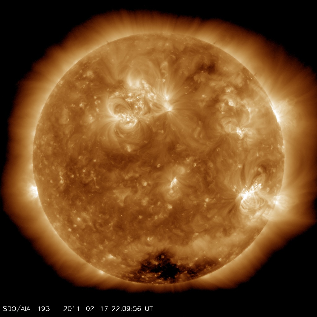
As a meteorologist, I not only monitor the weather down here on our own planet, but that of our solar system, especially the sun!  Activity on the sun roughly follows an 11-year cycle, and the sun has been relatively dormant for several years.  Now, our sun is starting to "fire" back up.  On February 14th, a class X solar flare, directed toward Earth, erupted from our sun along with coronal mass ejections (CME's - basically large blobs of plasma).  The flare reached our atmosphere on the 17th where they interacted with Earth's magnetic field and caused geomagnetic storms.  While this caused some spectacular auroras in the Arctic circle, it also wiped out radio communications in the Western Pacific Ocean and parts of Asia and caused several airline to reroute polar flights to avoid radio outages.

Image of the sun from Feb. 17th, 2011, 4:09 PM CST.
 NOAA scientists are now warning that the increased activity in space weather (a.k.a solar activity) could pose serious problems here on Earth in the coming years (the solar maximum or peak in activity is expected around the year 2013).  A severe solar storm not only has the ability to interrupt radio communications around the globe, but has the ability to take down all telecommunications and power grids (yes... even this will even effect all cell phone communications!).  Noaa administrator Jane Lubchenco is urging that the country needs to work on being better prepared for such an occurance.  Lubchenco said "This is not a matter of if, it's simply a matter of when and how big...  We have every reason to expect we're going to be seeing more space weather in the coming years, and it behooves us to be smart and be prepared."

Experts say that we were fairly lucky with our most recent solar storm in mid-February.  Our space weather hasn't posed quite such a threat in the past.  During the last solar maximum close to 10 to 11 years ago, our world wasn't as dependent on satellite communications, cell phones, and GPS - all of which could be disrupted by solar flares.

Our power grids are also a cause for concern.  If a solar storm were to damage them, there could be power outages for days, weeks, months, or even longer!  In March of 1989, a solar storm impacted Earth's magnetic field and caused a massive black out over the Quebec province of Canada for up to 9 hours!  Much needs to be done to better prepare our systems in the event of a major solar storm.

With all the risk, there is still a reason to be optimistic about the jump in solar activity.  Work is currently being done to improve the ability to forecast solar storms in advance, install more radiation shielding on satellites, and fortify power grids with more resilient transformers and capacitors.

Now I must stress that you shouldn't worry about this and begin to panic.  Scientists and other experts in the nation are hard at work in fortifying our systems.  So please sit back and relax.  And as Stephan Lechner from the European Commission's Joint Research Centre said (and I really like this quote!), "Please don't leave the room and tell everybody that space weather will kill us tomorrow."

Enjoy the winter weather.... Spring is almost here!

If you would like to follow the ongoing space weather, go to http://www.spaceweather.com/

Monday, February 7, 2011

Clouds... Our Winter Weather Friends

Hey There!  Sorry it's been a while since I've posted, but there has been much to do.  Storm systems to monitor, cold air to track - it seems like it's never ending.  Over this week, arctic air will filter into the region, dropping our temperatures as our cloud cover retreats to the east.  However, the influx of the cold air is not the only reason for the cool down.

Today I was asked: "How does clearing up (as it the clearing of the skies) make it cooler?"  Well, it's best and easiest to compare our cloud cover to a blanket on your bed.  The clouds trap the heat from the Earth during the day, and hold it in the lower levels of the atmosphere at night instead of letting it radiate out into space.  The more holes you have in the cloud cover (or blanket), the less efficient it is to trap the heat produced underneath.  Thus on a clear night, there is no "blanket" and all of our heat stored up during the day is allowed to radiate to space quickly, cooling us off.  (This is known as radiational cooling.)

So even though a thick cover of clouds make it seem gloomy outside during the winter, they help to moderate our temperatures at night.  So it's not all bad.  Just think of them like a blanket, you want them during the night while you sleep, but hope they disappear during the day (only to hopefully return just before sundown).

Have a great day!

Wednesday, January 12, 2011

Thunderstorms Produce..... Antimatter???

Apparently thunderstorms do produce anti-matter!  A recent study released by NASA has shown that lightning from thunderstorms here on Earth actually produces anti-matter that is sent out into space!  For more on this, go to following article: http://science.nasa.gov/science-news/science-at-nasa/2010/11jan_antimatter/

I realize this will most likely be over some people's heads, but it's really cool!

Friday, January 7, 2011

It's all down hill from here!

Well, we made it!  After today, things should slowly become a whole lot better.  You may be wondering what I'm talking about.  Well, I'm referring to our climatic average high and low temperatures.  We (at least in the Coulee Region) have hit our coldest average high and low temperatures for the season.  From this point forward, these two numbers that you constantly hear about on weather reports will start to climb as we head through February and into the spring months of March and April!

But I need to make one clarification here.  This does not mean we are entirely through with the cold weather.  To understand why, I need to tell you the what exactly I mean by the average high and low temperatures.  The average high and low temperature are actually the normalized high and low temperatures over the past 30 years (sometimes longer!  Meteorologist and climatologists use the past 30 years as a good period for a current climatic average).  Thus, the average high and low are actually a statistical average over that 30 year period of time!  Therefore, any exteme cold or heat that we have seen on a given day in the past (like in 1996 when the low was around -30F at the end of January/early February) would alter the average high and low temperatures for that day, but not by a whole lot, especially given 30 years of data. 

Thus, on one hand, things are looking brighter - it will soon be getting warmer since the average highs and lows are rising.  However, we could still have a cold snap.... so don't put that parka away just yet!

Sunday, January 2, 2011

Winter Weather Trivia #1 Answer

I asked you:

True or False. It must be 32°F or colder for it to snow.

Well, the answer is: False. It has been known to snow with temperatures in the mid 40's. Temperatures are below 32°F up in the clouds where the snow is forming.